
Storm Goretti map reveals where heaviest snow will fall across Derby, Derbyshire, Midlands

It is the first storm of 2026
The weather is not set to get any milder as Storm Goretti looms on the horizon.
The Met Office says Storm Goretti is likely to bring heavy snow across the region leading to disruption and difficult travelling conditions.
This latest Met Office yellow weather alert is between 6pm on Thursday January 8 till 12pm on Friday January 9.
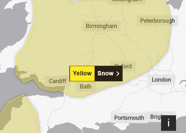

Areas affected by the weather warning include Derby, Leicester Lincolnshire, Northamptonshire, Nottingham and Rutland.
People can expect possible travel delays on roads and air travel, some rural communities could become cut off and power cuts may occur impacting mobile phone coverage.
What is Storm Goretti?
Meteo France has named the system as the strongest winds associated with Storm Goretti are most likely over northern France.
In the UK, a deep area of low pressure will move across the south during Thursday and into Friday bringing a mixture of rain, snow and strong winds.
Rain will turn to snow during Thursday night. In some areas, 5-10 cm of snow may settle with the potential for up to 20 cm in some locations, especially over higher ground. Strong winds may lead to some drifting of snow. Rain and snow will then clear eastwards during Friday.
How long will snow last for in Derby?
Met Office Chief Meteorologist, Matthew Lehnert, said: “The UK will continue to experience a range of winter weather hazards through this week, with low temperatures as well as snow showers and the risk of ice for many.
“A number of severe weather warnings have been issued and these are likely to be updated through the week so do keep up to date with the forecast.”
It is set to be a windy week ahead filled with heavy rain and blustery conditions.
There is some uncertainty over the exact position of a low pressure system which is key to understanding potential weather hazards.
Deputy Chief Meteorologist, Mike Silverstone, said: “While we’re confident an area of low pressure will move in from the west on Thursday and into Friday, the exact position of that low pressure is uncertain at this stage. The position is important as it will determine the type of severe weather different locations may experience.
It has been a cold start to 2026 with numerous weather and cold alerts.
These include an amber cold alert issued by the UK Health Security Agency (UKHSA) for all regions of England, in place until Saturday January 11.